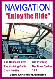
Navigation – Enjoy The Ride -DVD
March 9, 2021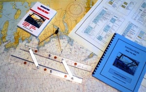

Safe, Legal, and Confident!

Navigation Course Kit ($90 Value)
$69.95
Includes: Full-size NOAA Chart, Instructional Video (On-line), Plotting Tools, (15″ Parallel Rule and 6″ Dividers), Course Book with Plotting Problems and Detailed solutions.
This Complete Navigation Course provides the instruction, plotting tools, charts, and the navigation problems and solutions for you to start developing your navigation skills.
Course Kit Includes:
- Navigation Instructional Video (On-line)
- Course Book
- Full Size NOAA Training Chart (37 x 44 inches)
- Chart No. 1; Chart Symbols and Abbreviations
- Plotting Problems and Solutions
- 15″ Parallel Rule
- Dividers
Selecting and reading nautical charts.The Course Book illustrates Navigation Techniques including:
- Chart Plotting
- Dead reckoning
- Piloting
- Determining Position
- Magnetic Compass Corrections
- GPS (Global Positioning System)
- Creating Waypoints
- Cross Track Error
- Trip Planning
- Reading Tides and Current Tables
- Effects of Current on Plotted Courses
The navigation problems presented in the coursebook are an excellent way to develop the navigation techniques illustrated in the coursebook. Courses are plotted by the student directly on the full-size (37 x 44 inch) NOAA training chart provided. Chart Number 1, which provides an explanation for all of the Symbols, Abbreviations, and Terms used on the chart, is printed on the reverse side of the chart.
The coursebook thoroughly prepares you to solve the plotting problems presented.
Plotting Problems include:
How to select the particular chart needed to enter an unfamiliar harbor.
Determine the Compass Course of a course-line you have plotted between two buoys.
Determine the exact distance of a trip plotted between two points.
Calculate the time required to get to your destination and the estimated time of arrival.
Determine your position in latitude and longitude at any given time during a trip.
Calculate the fuel needed to complete your trip.
Identify the depth of water and the quality of the bottom at a given time during your trip.
Determine the latitude and longitude coordinates of a buoy you want to enter into your GPS as a waypoint.
Determine your position in latitude and longitude by taking compass bearings to a lighthouse and water tower you see on land.
Determine how to adjust your plotted course to offset the effect of a cross current.
Determine the Compass Course, Magnetic Course, and True Course of a rhumb line plotted between two buoys based on the local variation and the vessel’s deviation table provided.
What time is slack water on January 10th after the first ebb tide? (Current tables provided.)
What is the maximum speed and direction of the flood tide on January 8th? (Current table provided.)
What is the time of low tide on January 6th? (Tide table provided.)
What are the time of high tide and the tidal range on January 7th? (Tide Table provided.)
Reviews
There are no reviews yet.